 Ismaila Abubakar
Department of City and Regional Planning
King Fahd University of Petroleum and Minerals
Dhahran, Saudi Arabia
This e-mail address is being protected from spambots. You need JavaScript enabled to view it
Yusuf A. Aina
Department of City and Regional Planning
King Fahd University of Petroleum and Minerals
Dhahran, Saudi Arabia
This e-mail address is being protected from spambots. You need JavaScript enabled to view it
ABSTRACT:
Accessibility as a relative nearness of one place to another indicates easiness of reaching destination from origin. As a spatial analytic measure, it plays a vital role for decision makers in deciding where to locate public facilities or amenities so as to maximise their usability. More accessible public facilities like parks and open spaces improve social cohesion and interaction as more people patronise them. Better accessibility to facilities also ensures economic efficiency in the use of such facilities because when they service more people, they would be more cost effective. One of such places where the location of green areas is meant to serve the above-mentioned purposes is Doha district in Saudi Arabia.
Doha is a new district in Dammam metropolitan region of Eastern Province of Saudi Arabia. It is designed in grid-iron pattern with some organised green areas in contrast with the old traditional organic settlements. The District is planned by Saudi Arabian Oil Company (ARAMCO) to serve as a model to the new and traditional settlements in the country. The green areas include parks and open spaces serving as public recreation centres. But are they accessible to their intended beneficiaries?
Some of the ways by which the accessibility of the green areas can be measured is by using Space Syntax or GIS Network Analysis techniques. The Network Analysis technique is based on distance measurement between the green areas and the neighbourhoods they serve, while the space syntax technique evaluates the spatial configuration of the green areas. This paper, therefore, identifies the locations of those green areas and analyses their level of accessibility using both techniques in a comparative approach. Lastly, recommendations were made on how GIS network analysis and space syntax can help in the location of public infrastructure in Saudi Arabia.
Introduction
Planners and other decision makers find it not easy to come to a conclusion on selecting the best site to locate public facilities like schools, hospitals, parks and green areas etc, in a city or neighborhood. Their major concern is that choosing a wrong location for a facility can make it less accessible and hence it might be underutilized or neglected by the community. Therefore, researchers have developed several means of evenly locating public facilities in such a way that the facilities will effectively benefit majority of people in the society. One of such various techniques and tools is using the accessibility measure.
Accessibility can be defined as the simplicity with which activities in the society can be reached, including needs of citizens, trade and industries and public services. Distance measures are the simplest accessibility measures, counting the distance from one location to different opportunities. It can be measured as average distance, weighted area distance or distance to the closest opportunity. The estimation of these distances can be performed in several ways, from simple straight-line distances to more complicated impedance formulations (Makri and Folkesson, 1999). The accessibility measures that are based on distance measurements can be considered as geographic accessibility measures and space syntax is one of the best tools of measuring that.
Space syntax is a methodology for representing the morphology of buildings, open spaces and streets. Space syntax models the spatial configurations of urban spaces by using a connectivity graph representation. Jiang et al, (2000) believes that space syntax provides a configurational description of an urban structure and attempts to explain human behaviors and social activities from a spatial configuration point of view. The syntactic measure of accessibility is regarded as geometric accessibility measure (Jiang et al., 1999). There is a growing debate on which approach is more dependable in measuring accessibility (Steadman, 2004). This study therefore, attempts to use green spaces in Doha to access the degree comparability of two approaches in measuring accessibility.
Originally, merely an aesthetic element in towns and cities, green space has now taken on a new value and function, the importance of which is widely acclaimed within the parameters of sustainable development. The presence of green spaces represents a fundamental asset above all when considering contemporary urban reality, with its traffic congestion, pollution and lack of space for socializing
The efficiency of urban green according to space lies largely in its overall structure – as an integral part of the entire system of green space throughout the whole metropolitan area – and in the function which it serves in relation to both the entire territorial context in which it is inserted, and to whom is envisaged to be using it.
The following play a particularly important role in the relationship between citizens and urban green: (a) behavior pattern; (b) the level of perception on the part of the residents towards the green system in their own city; and (c) the social representations which they construct within their own social context. On the other hand, the urban system of green spaces has forced its way into urban development thinking on relationships and the elimination of urbanistic, architectural and social barriers. It has now become a citizens’ right to have green urban spaces incorporated into city planning.
The paper, therefore, evaluates the accessibility of green areas in Doha Districts using geographic and geometric measures. It also examines the similarity or otherwise of the measures in a view to contribute to the debate on the dependability of the methods.
Study area
Doha district is a neighbourhood in the Dammam Metropolitan Area of the Eastern Province of Saudi Arabia. It is located about 3km northeast of Dhahran and approximately 5 km from the Arabian Gulf. The settlement was established by Saudi Aramco Oil Company in the seventies to accommodate the high demand for housing necessitated by industrial expansion due to oil boom. The town housed mostly staff of the company which owns the land and distributes it to its staff as part of home ownership community development scheme. Aldossary (2002) is of the opinion that it is the largest single home ownership area in the kingdom. The oil company carried out the planning and provision of facilities and infrastructure to serve the public. The layout plan, as we mentioned before, is arranged in grid-iron pattern with provision of community services like mosques, schools and green spaces for recreation. This inspires the design of many town and district in the kingdom in a similar pattern. There are eleven green areas located in various parts of the district serving over 37,000 houses as of 2002 (Aldossary, 2002) as well as commercial centres, schools and other services. The following figure shows the location of Doha in Saudi Arabia.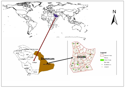
Fig 1: The location of Doha District, Saudi Arabia
Theoretical framework
The measure of accessibility depends on the representation and the methodology used in deriving accessibility. Accessibility can be depicted as place accessibility or individual accessibility depending on the consideration of individual choices and opportunities in the framework. The place accessibility, which is the common way of operationalizing accessibility, is derived from the transportation system (distance, cost or time) and the attractiveness of the activity centre (Makri and Folkesson, 1999).
Different methods are adopted in deriving place accessibility depending on the area of application and data. Place accessibility is usually determined by integral measures that include distance measure, gravity measure, cumulative opportunity measure and utility-based measure (Makri and Folkesson, 1999). All the aforementioned measures are regarded as geographic measures ((Jiang et al., 1999) because they are based on 'node-link' representation of transportation network and metric distance measurements (Steadman, 2004). Another approach to measuring place accessibility is the space syntax. Unlike the geographic measures, space syntax measures are based on network configuration.
Space syntax measures geographic accessibility with axial lines. Axial lines are lines of unobstructed movement used in computing accessibility. The first representation, a so called axial map, is defined as the least number of longest straight lines. According to how each line intersects every other line, a connectivity graph, taking axial lines as nodes and line intersections as links, can be derived. Different configuration parameters are computed from the axial map.
Connectivity is the most apparent parameter for morphological analysis. Connectivity is defined as the number of nodes directly linked to each individual node in the connectivity graph. The second parameter is the control value,
Control value is defined as a parameter which expresses the degree of choice each node represents for nodes directly linked to it. The third parameter is integration.
Integration of a node is by definition expressed by a value that indicates the degree to which a node is integrated or segregated from a system as a whole (global integration), or from a partial system consisting of nodes a few steps away (local integration) (Jiang et al, 2000).
The "node-link'' geographic approach has been criticized for failing to take account of the network configuration while the geometric method has also been criticized for not considering metric distance (Stedman, 2004). However, Stedman (2004) argued that in a broad sense the two approaches are similar. It is imperative to further investigate the similarity of the approaches especially noting their consistency in measuring accessibility.
Benefits of green areas to urban dwellers
Green spaces no longer figure merely as a decoration, but act as an ecological environmental system, carrying out a wide range of social functions and services. Besides being used as places for leisure, recreation, games and sporting activities, green spaces can indeed generate an elevated level of social participation and collaboration between fellow citizens. Various studies have been carried out, for example, on green areas as places of social aggregation, reduction of conflict between rival groups of young people and reduction of aggression to public property (Sanesi and Chiarello, in press).
Urban green space can help substantially in making life in cities more agreeable. This will reverse the trend of growing social segregation due to urban sprawl. It is mainly the middle to high-income households that have moved to the urban fringes, leaving concentrations of financially modest families in the inner city, where economic disadvantage and unemployment are concentrated as well. Therefore, making cities more attractive will promote social integration. Furthermore, the creation of green networks for the promotion of cycling and walking will benefit to the weak road user and to people with limited mobility. There will also be more equity between different social classes if accessibility depends less on car possession.
Urban green space has been recognized for the social functions that it fulfils, in terms of meeting places and areas for entertainment, recreation and relaxation, and its amenity value including contribution to quality of life, aesthetic enjoyment, a feeling of security and freedom from urban noise and pollution. There exist strong links between poor environmental quality and health.
Urban greenery also helps to constitute a framework where urban society and culture can develop, and to increase identity and a sense of community. It can be used to provide a ground for education and awareness in relation to the way ecosystems function and how urban functions can be integrated into the natural system.
Importance of Accessibility in locating public facilities
Planning is concerned with equity and a better distribution of people and activities in the society. That is why accessibility, regardless if it is measured in time, cost, distance, or population, is the most important variable that one must consider in the early stages of planning.
Integrated and accessible spaces (like green areas) will, according to the theory of natural movement, play a more central role in the urbanity. These spaces will not only be more frequently visited and used, they will also probably get better known because they are located in more legible places and at the same time within the people’s daily movement patterns (Stahle, 2005).
In a city, a town, a village or a neighborhood, free space is stretched in one orientation at most points. When humans are walking in this type of free space, at most points (if not all) such a free space is perceived as a ‘vista’ that can promote livability and good memory of the city.
Methodology and Results
In this study geometric (space syntax) and geographic (network analyst) techniques were used in evaluating the accessibility of urban green areas in Doha district and the results of both methods are compared to determine their similarity. In both methods, the road junctions by the green areas are used as nodes and the roads linking them with the residential and commercial areas in the district are used as axes. The methods, procedures and the outcomes are explained below:
GIS (Network Analyst): Network Connectivity defines how features that participate in a network connect to each other. The default connectivity for a network dataset places all sources in one connectivity group and assigns all endpoints or activity points to the (destination) connectivity.
Gravity measures: Gravity-based measures obtained by weighting opportunities in an area with a measure indicating their attraction and discounting them by impedance measure (Makrí and Folkesson, 1999). The integral accessibility Ai, using gravity measure, for the green area i is measured as:
Ai = ∑aj *f (dij) Ai = Accessibility of Green area i aj = Attraction to green area (size in square meters) dij = is the travel time, distance or cost from zone i(Source) to zone j (destinations)
Procedure: ArcGIS version 9.1 network analyst is used for the project and the following are the procedures followed.
- Doha Geodatabase is created and the shapefiles of the buildings, roads, green areas and service areas are prepared
- Creation and building of Doha road network dataset from roads shapefile using ArcCatalog
- Setting up of connectivity model for the network,
- Creation of destination points based on the road junction that is closest to the green area.
- The study area is divided into 24 service areas of between 2.7- 4.0 hectares and the approximate center of each area is used as the source/origin points of the analysis (fig. 2).
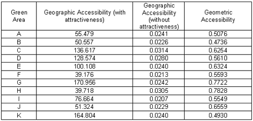
- Then the program is run to calculate the distances from the origins to the destinations. Then, the accessibility for each destination (green area) is computed (table 1).
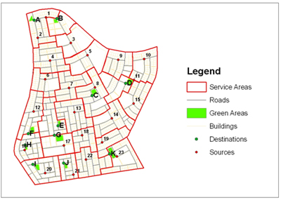
Fig 2: The Green Areas and the Sources
Space Syntax technique: The analysis is carried out using a generalized space syntax programme. Axial lines are used to represent roads and streets while nodes represent road junctions. The program is AJAX-Light version 1.02 developed by Michael Batty of Centre for Advanced Spatial Analysis (CASA), University College London.
Procedure: AJAX-Light version 1.02 is used in the analysis of junctions and axial lines connecting the green areas. The procedure is as follows
- The road network and the road junctions (created automatically by ArcMap) shapefile were exported as JPEG image to be used as input in AJAX
- The program is used to draw both the axial lines and the nodes. The program computes axial line and Junction analysis.
- The results of the analyses for integration value of the junctions or nodes are saved and also the accessibility values of the axial map (fig 3).
- The accessibility scores for all the nodes are saved and those of the 11 green areas are taken for analysis
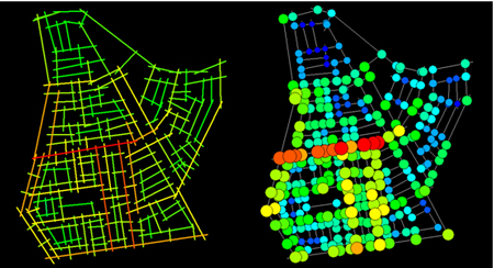
Fig 3: Axial and Junction Analysis Map
Table 1 shows the results of the accessibility analysis. Column 1 is the geographic accessibility measure with attractiveness (area of green areas) incorporated. Column 2 is the geographic accessibility measure without attractiveness. Column 3 is the geometric accessibility measure. The values of the accessibility measures for the green areas are very close except for Column 1 whereby the area (attractiveness) influenced the measures. The results indicate that the green areas are located in places with almost equal potential accessibility. However, if the whole neighbourhood is considered, it reveals that the green areas have not been located in the optimum accessibility places. For instance, the syntactic analysis indicates that some junctions have higher accessibility values than the junctions of the green areas. The highly accessible places are locations of commercial activities which buttresses the argument that economic activities are located in highly legible (integrated) places.
In order to compare the two approaches, a null hypothesis that there is no significant difference in the mean accessibility measures of the eleven green areas using network analyst method and that of Space syntax is developed as follows:
![]()
The alternate hypothesis is that there is significant difference in the means of the two accessibility measures. The analysis was conducted using T-test at 90% level of significance. The results are as follows:
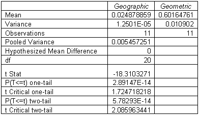
The comparison result shows that the t Statistics is less than the t Critical for both one-tail and two-tail. Therefore, the null hypothesis is accepted that there is no significant difference between the geographic and the geometric measures. It indicates that there is similarity between the potential accessibility measures of syntactic analysis and geographic analysis (gravity measure).
Conclusion and recommendation
Green areas are very important public facilities that improve the aesthetic values of the society, improve social interaction and recreation. In the desert environment like Saudi Arabia, green areas are good sight and temperature moderators. The study shows the potentials of using space syntax and GIS in urban morphological analysis. The results reveal that there is a similarity in the outcome of the two analyses done with GIS Network Analyst and space syntax. This shows that the two techniques are comparative or complementary to each other. Space syntax and or GIS Network Analyst are useful tools that can aid municipalities and other urban development agencies in deciding the optimum location in for public facilities and infrastructure. This study also proves that the planned modern settlements provides more accessible public infrastructure.
Other important factors to be taken into cognisance in further research of this kind are the population density of various neighbourhoods in the study area as well as the presence of other public facilities like school that can make the use of the green areas.
Acknowledgement
The authors acknowledge the support of King Fahd University of Petroleum & Minerals, Saudi Arabia for providing various facilities in carrying out this study.
Reference:
Results:
- Aldosary, A. S. (2002) Testing the Planned City Approach: An assessment of the Effectiveness of Infrastructure Planning Standards in a Saudi Arabian City. International Journal of Management; Vol. 19 No. 2 (1)
- Batty, M. and Rana, S. (2002) Reformulating Space Syntax: The Automatic Definition and Generation of Axial Lines and Axial Maps. Centre for Advanced Spatial Analysis, University College London http://www.casa.ucl.ac.uk/
- Jiang, B., Claramunt, C. and Batty, M. (1999) Geometric Accessibility and Geographic Information: Extending Desktop GIS to Space Syntax. Computers, Environment and Urban Systems; 23, 127-146
- Jiang, B., Claramunt, C. and Klarqvist, B. (2000) Integration of space syntax into GIS for modeling urban spaces. JAG; Vol. 2, Issue 3/4.
- Makrí, M. and Folkesson, C. (1999) Accessibility Measures for Analyses of Land Use and Traveling with Geographical Information Systems. Proceedings of 2nd KFB-Research Conference, Lund Institute of Technology, Lund. www.tft.lth.se/kfbkonf/4Makrifolkesson.pdf
- Sanesi, G and Chiarello, F. (In press) Residents and urban green spaces: The case of Bari. Urban Forestry & Urban Greening.
- Stahle, A. (2005) Park Syntax - Measuring Open Space Accessibility and Smart Growth. Short paper to the 5th Space Syntax Symposium,
- Stedman, P. (2004) Guest Editorial – Developments in Space Syntax. Environment and Planning B; 31, 483-486.


